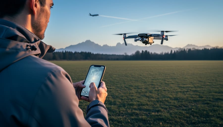
Check your drone’s registration status with the FAA before every flight—recreational drones weighing over 0.55 pounds require registration, and flying unregistered can result in civil penalties up to $27,500. Download the B4UFLY mobile app to get instant airspace status for your exact location, identifying controlled airspace, temporary flight restrictions, and whether you need authorization before launching. Verify your flight altitude stays below 400 feet in uncontrolled airspace, as this is the maximum legal ceiling for recreational drone operations in the United States.
Understanding drone airspace isn’t just about avoiding fines—it’s about protecting your ability to capture stunning aerial photographs while keeping our skies safe. The airspace above us is divided into distinct classifications, each with specific rules that determine whether you can fly, where you can fly, and what permissions you need first. For drone photographers, navigating this regulatory landscape can feel overwhelming, especially when you’re standing at a breathtaking location wondering if you’re legally allowed to launch.
The good news is that once you understand the basic framework, checking airspace becomes second nature. Most popular photography locations fall into predictable categories, and the tools available today make real-time authorization surprisingly straightforward. Whether you’re shooting real estate, landscapes, or creative aerial compositions, knowing your airspace responsibilities protects your investment in equipment, keeps you legally compliant, and ensures you can focus on what matters most—capturing extraordinary images from perspectives that were impossible just a decade ago.
What Is Drone Airspace? (And Why It Matters for Your Photography)
Think of drone airspace as invisible highways in the sky, each with its own speed limits and traffic rules. Just as you wouldn’t drive your car anywhere you please on the ground, your drone can’t fly just anywhere above it. Understanding this concept is essential for capturing those stunning aerial shots legally and safely.
At its core, drone airspace refers to the three-dimensional zones above us, divided into categories based on aviation safety requirements. The two main types you need to know are controlled airspace and uncontrolled airspace. Controlled airspace exists around airports and in busy flight corridors where air traffic control manages the flow of aircraft. Uncontrolled airspace typically covers rural areas and regions away from major aviation activity, where fewer restrictions apply.
Here’s why this matters for your photography. That gorgeous beach you’ve been eyeing for a sunset drone shoot? If it’s far from airports and not in a restricted zone, you’re likely looking at uncontrolled or less restrictive airspace where flying is straightforward. But that impressive cityscape near the regional airport? That’s probably controlled airspace requiring special authorization before you can launch.
The framework governing drone flights comes primarily from aviation authorities like the FAA in the United States. They’ve established these zones to prevent conflicts between drones and manned aircraft, which obviously take priority. The basic principle is simple: the closer you are to airports, helipads, or designated sensitive areas, the more restricted the airspace becomes.
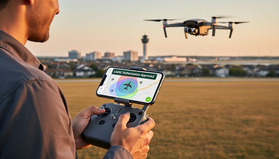
This doesn’t mean you can’t photograph near controlled airspace. It means you need authorization first, typically through apps like LAANC (Low Altitude Authorization and Notification Capability), which can grant permission in minutes for many locations. Understanding these boundaries before you arrive at your shoot location saves frustration and keeps you compliant. The difference between a successful photography session and a wasted trip often comes down to checking airspace classifications beforehand.
The Five Types of Airspace Every Drone Photographer Should Recognize
Class B, C, and D: The Controlled Zones Around Airports
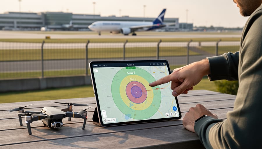
Around most airports, you’ll encounter three distinct layers of controlled airspace that directly impact where you can fly your drone. Think of these zones as concentric circles of increasing restriction, each designed to protect aircraft during different phases of flight.
Class B airspace surrounds the busiest airports in the country—think places like Los Angeles International or Chicago O’Hare. These zones typically extend from the surface up to 10,000 feet and spread outward in a tiered structure, sometimes reaching 30 miles from the airport. For drone pilots, Class B is essentially off-limits without explicit Air Traffic Control authorization, which is rarely granted for recreational photography.
Class C airspace covers moderately busy airports with significant commercial traffic. These zones usually extend from the surface to 4,000 feet above the airport elevation, with an outer ring stretching about 10 miles from the runway. While slightly less restrictive than Class B, you’ll still need ATC authorization before launching your drone here.
Class D airspace encircles smaller airports with control towers. These zones are more manageable, typically extending 5 miles horizontally and up to 2,500 feet vertically. Authorization requirements apply here too, though approval rates tend to be higher for recreational flights.
Here’s the practical reality: before every shoot, you need to verify your location against these zones. The FAA’s B4UFLY app provides real-time airspace information based on your GPS coordinates. Simply enter your shooting location, and the app instantly shows whether you’re in controlled airspace and what authorization you’ll need. Many drone pilots also use apps like AirMap or Aloft for more detailed planning, which overlay airspace boundaries on interactive maps and streamline the authorization request process through LAANC (Low Altitude Authorization and Notification Capability).
Class G: Your Best Friend for Aerial Photography
Class G airspace is where most drone photographers find their creative freedom. This is uncontrolled airspace, meaning you won’t need air traffic control authorization to fly here. Think of it as the open road for your drone—but that doesn’t mean there aren’t rules to follow.
In most areas away from airports and restricted zones, you’re operating in Class G airspace. Here, recreational and commercial drone pilots enjoy the most flexibility, making it ideal for landscape photography, real estate shoots, or just experimenting with new aerial techniques.
The golden rule? Stay at or below 400 feet above ground level. This ceiling keeps drones well below manned aircraft traffic patterns while giving you plenty of altitude for dramatic perspectives. For context, 400 feet is roughly the height of a 40-story building—more than enough for most photography needs.
Even in Class G, you’ll need to maintain visual line of sight with your drone, avoid flying over people not directly involved in your operation, and never operate from a moving vehicle unless you’re in a sparsely populated area. You’ll also need to check for temporary flight restrictions, which can pop up for events like sporting games or wildfire operations.
Bottom line: Class G offers the easiest access for aerial photography, but responsible flying practices always apply.
Special Use Airspace: The Hidden Restrictions
Beyond the standard airspace classifications, Special Use Airspace creates additional layers of complexity that can catch drone photographers off guard. These restrictions exist for genuine safety and security reasons, but they’re not always obvious on the ground.
Military Operations Areas, or MOAs, are common around military installations where training exercises occur. While these primarily affect manned aircraft, some MOAs extend to ground level and require drone pilots to exercise extreme caution. Similarly, restricted areas around places like Camp David or military bases are strictly off-limits, with violations potentially resulting in serious legal consequences.
Temporary Flight Restrictions are the sneakiest culprit for photographers. TFRs pop up with little notice for events like presidential visits, wildfire suppression efforts, or major sporting events. That picturesque stadium you planned to photograph? It likely has a TFR during game day. National parks present another common scenario—places like Yosemite and the Grand Canyon are photographer magnets, yet drone flights are completely prohibited.
Before every shoot, check NOTAM (Notice to Airmen) databases through apps like B4UFLY or AirMap. These tools overlay TFRs and special use airspace on maps, showing exactly what’s active in your area. What looks like a perfect shooting location on Google Maps might be temporarily or permanently restricted, so this pre-flight research isn’t optional—it’s essential for staying legal and keeping everyone safe.
Recreational vs. Commercial Drone Photography: Different Rules for Different Shoots
The Part 107 License: When You Need It and What It Allows
If you’re planning to turn your drone hobby into a business—whether that means commercial drone photography for real estate, weddings, or selling your aerial images as stock photography—you’ll need to obtain your Part 107 license from the FAA. This isn’t just a formality; it’s a legal requirement the moment you accept any form of compensation for your drone work.
The Part 107 certification opens doors that recreational flyers don’t have. With it, you can legally operate in certain controlled airspace (with proper authorization through LAANC), fly during twilight hours with appropriate anti-collision lighting, and conduct operations that generate income. You’ll also gain a deeper understanding of weather patterns, airspace classifications, and operational safety that makes you a more confident pilot.
Getting certified requires passing a knowledge test covering topics like airspace regulations, weather theory, flight operations, and emergency procedures. The test costs $175 and can be taken at any FAA-approved testing center. Most photographers find that 10-15 hours of study using online courses or FAA materials is sufficient preparation. You don’t need to be a licensed pilot or have prior aviation experience.
Once certified, your license is valid for two years, after which you’ll need to complete a recurrent training course. Think of Part 107 as your professional credential—it not only keeps you legal but also demonstrates to clients that you’re a serious, knowledgeable operator who prioritizes safety and compliance.
The Recreational Exception: Simple Rules for Hobbyists
If you’re flying purely for fun, the FAA has created a streamlined path that keeps bureaucracy to a minimum. Under the recreational exception, hobbyist drone photographers must follow a handful of straightforward rules that balance safety with creative freedom.
First, registration is non-negotiable. Any drone weighing between 0.55 and 55 pounds needs to be registered with the FAA, which costs just $5 and takes about five minutes online. You’ll receive a registration number to display on your aircraft—think of it as a license plate for your drone.
The operational rules are equally simple. You must keep your drone within visual line of sight at all times, meaning no flying beyond what you can see with your own eyes. Stay below 400 feet in altitude, and never fly near other aircraft or in controlled airspace without proper authorization. Night flying requires anti-collision lighting visible for three miles.
Here’s a real-world example: imagine you’re photographing a sunset at your local park. As a recreational flyer, you can capture those golden hour shots as long as you maintain visual contact with your drone, stay under the 400-foot ceiling, and avoid flying over people who aren’t directly participating in your shoot. Many recreational pilots use apps like B4UFLY to quickly check whether their chosen location falls within restricted airspace before launching.
LAANC: Your Fast Pass to Controlled Airspace
How to Get Authorization in Minutes (Not Months)
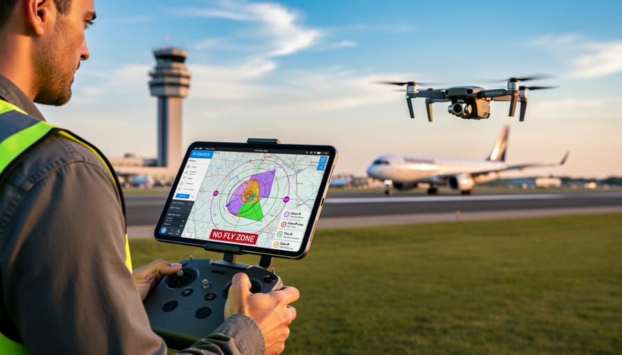
Gone are the days of waiting weeks or months for airspace authorization. The FAA’s LAANC (Low Altitude Authorization and Notification Capability) system has revolutionized how drone pilots get permission to fly in controlled airspace, reducing what used to be a 90-day wait to just seconds in many cases.
LAANC works through approved mobile apps that connect directly to the FAA’s system. When you’re planning a shoot near an airport, simply open one of these apps, select your location, specify your intended altitude and flight time, and submit your request. The system automatically checks if your flight falls within pre-approved parameters and issues instant authorization if you’re clear.
The most popular LAANC apps among photographers include Aloft, AirMap, and Kittyhawk. Each offers a similar core function but with different interfaces. Aloft stands out for its intuitive map interface that color-codes airspace restrictions, making it easy to visualize where you can fly and at what altitude. AirMap excels at flight planning features, letting you save favorite locations for repeat shoots. Kittyhawk offers robust flight logging, which is helpful for professional photographers tracking their operations.
Here’s a practical workflow for your next shoot: Before leaving home, open your LAANC app and check the airspace around your intended location. You’ll see maximum approved altitudes displayed on the map, often broken into grid squares. If you need authorization, submit your request at least an hour before your shoot, though many approvals come through instantly. Save the authorization confirmation on your phone since you’re required to present it if asked by authorities.
One important tip: LAANC doesn’t work everywhere in controlled airspace. Some areas near airports require traditional manual authorization through the FAA’s DroneZone portal, which still takes time. Your LAANC app will tell you if manual authorization is needed, so always check before planning complex shoots in these locations.
When LAANC Can’t Help: Manual Authorization Requests
Not every airspace authorization happens instantly. While LAANC works wonderfully in many controlled airspace zones, some situations require traditional manual authorization through the FAA’s DroneZone portal. This typically happens in areas where LAANC hasn’t been implemented yet, near certain military installations, or when you need to fly higher than the maximum altitude LAANC allows for that specific grid.
Here’s the catch: manual authorizations can take anywhere from several weeks to potentially 90 days for processing. I learned this the hard way when planning a real estate shoot near a small regional airport without LAANC coverage. What I thought would be a quick approval turned into a three-week wait.
The key to navigating manual authorizations is advance planning. If you’ve identified a location that requires this route, submit your request at least 90 days before your intended shoot date. Include detailed information about your proposed flight area, altitude requirements, and the purpose of your flight. The more specific and professional your request, the smoother the process typically goes.
For commercial photographers booking client work, always check airspace requirements during your initial location scouting. Build authorization timelines into your project schedule, and consider having backup locations that offer LAANC access. This planning approach has saved me from disappointed clients and lost opportunities more times than I can count.
Essential Tools for Checking Airspace Before Every Flight
Before you launch your drone for that golden-hour landscape shot or architectural photography session, checking airspace restrictions should be as routine as checking your battery level. Fortunately, several excellent tools make this process straightforward, even if you’re new to aviation regulations.
The FAA’s official B4UFLY mobile app remains the gold standard for quick airspace checks. Available for both iOS and Android, it provides real-time information about flight restrictions at your location using GPS coordinates. Simply open the app, and it instantly shows whether you’re in controlled airspace, near temporary flight restrictions, or clear to fly. The interface uses a simple color-coded system—green means go, yellow means caution and possible authorization needed, and red means no-fly zone.
For photographers planning shoots in advance, Aloft (now part of Kittyhawk) offers more detailed planning features. You can save locations, view detailed airspace layers, and even submit LAANC authorizations directly through the app when shooting near airports. This is particularly valuable when coordinating client shoots days or weeks ahead.
AirMap is another robust option that includes real-time advisories about temporary restrictions like sporting events, wildfires, or VIP movements—situations that might not appear on standard sectional charts but could ground your shoot unexpectedly.
For those who want to understand the bigger picture, traditional aviation sectional charts (available through the FAA website or apps like SkyVector) provide comprehensive airspace visualization. While they look intimidating at first with their magenta circles and blue lines, spending thirty minutes learning to read them gives you valuable context about the airspace environment around your regular shooting locations.
Here’s a practical pre-flight workflow: Check B4UFLY for immediate status, verify with Aloft or AirMap for any temporary restrictions, and if you’re shooting commercially or in unfamiliar territory, cross-reference with sectional charts. This three-layer approach takes just minutes but provides comprehensive coverage, ensuring your focus stays on capturing stunning imagery rather than regulatory headaches.
Common Photography Locations and Their Airspace Challenges
Urban Landscapes and City Centers
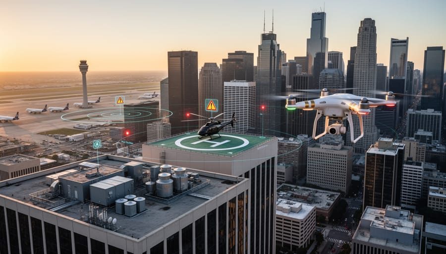
Cities present some of the most visually compelling drone photography opportunities, but they’re also where airspace restrictions are strictest. Most urban centers sit within controlled airspace due to proximity to airports, heliports on hospital rooftops, or other aviation facilities. Before you launch, check your drone app’s airspace map—you’ll likely see overlapping restricted zones that require authorization.
The key is advance planning. In controlled airspace, you’ll need LAANC authorization (Low Altitude Authorization and Notification Capability) in the U.S., or equivalent permission in other countries. Many apps process these requests instantly for approved altitudes, but don’t assume approval. Some zones remain off-limits entirely.
For compliant urban shots, scout elevated public spaces outside restricted zones. Parks on hillsides, waterfront areas, and suburban neighborhoods often offer skyline perspectives without airspace conflicts. Industrial districts can provide dramatic angles with fewer restrictions than downtown cores.
Consider rooftops where you have permission—not only does this solve understanding property rights concerns, but launching from higher ground often places you outside ground-level obstacles while maintaining legal altitude limits. Always verify local ordinances, as some cities impose additional restrictions beyond federal airspace rules. When in doubt, contact local aviation authorities before your shoot.
National Parks, State Parks, and Public Lands
Flying your drone over stunning landscapes sounds straightforward until you realize that national parks, state parks, and public lands each operate under different rules. While the FAA controls the airspace above these areas, the land management agencies control what happens on the ground—and this is where things get complicated.
The National Park Service generally prohibits drone launches, landings, and operations within park boundaries, regardless of airspace classification. This means even if you’re in uncontrolled airspace, you can’t legally take off from inside Yellowstone or Yosemite. However, you might legally fly over certain parks if you launch from outside the boundaries and the airspace permits it—though this remains a legal gray area and isn’t recommended.
State parks follow varying regulations depending on the state. Some allow drone use with permits, others ban it outright, and some have no specific rules at all. Before planning your shoot, check both the state park’s website and contact the ranger station directly.
Bureau of Land Management (BLM) and National Forest lands are typically more permissive, often allowing recreational drone use without special permits. These areas can offer incredible photography opportunities while keeping you compliant.
The key distinction to understand: airspace authority doesn’t override land-use restrictions. Just because the FAA says you can fly in Class G airspace doesn’t mean the land manager allows drone operations. This intersects with broader property rights issues that photographers must navigate. Always research both layers before arriving at your location.
Events, Stadiums, and Crowded Gatherings
Large gatherings attract Temporary Flight Restrictions (TFRs) that can ground your drone without warning. Stadium events, concerts, and crowded venues often trigger these restrictions, typically extending one nautical mile from the venue and up to 1,000 feet in altitude. Major sporting events like NFL games automatically generate TFRs starting one hour before and ending one hour after the event.
Here’s the catch: TFRs can pop up with minimal notice, sometimes just 24 hours before an event. That beautiful sunset shot you planned near the stadium? It could be illegal if there’s a game that evening.
Before every flight, check the FAA’s TFR map at tfr.faa.gov or use apps like B4UFLY, which consolidate airspace restrictions into user-friendly formats. These tools show active and upcoming TFRs, helping you plan shoots around restrictions rather than discovering them mid-flight.
Consider this real-world scenario: A photographer planned to capture a music festival from above, only to find a TFR covering the entire venue. The solution? She contacted the event organizers weeks in advance and coordinated with local authorities for a waiver, ultimately getting approved flight windows during setup hours.
The takeaway: Always check restrictions the morning of your shoot, even if you checked days earlier. TFRs change, and staying informed protects both your equipment investment and your legal standing.
What Happens When You Fly Illegally (And It’s Worse Than You Think)
The consequences of flying illegally are more serious than many photographers realize. The Federal Aviation Administration doesn’t just issue warnings—they enforce regulations with financial penalties that can reach $30,000 for civil violations. In egregious cases involving reckless operation or interference with emergency services, criminal charges can result in fines exceeding $250,000 and potential imprisonment.
Consider the 2017 case of a California drone operator who flew near firefighting aircraft during a wildfire. Not only did he face federal charges, but his actions delayed aerial firefighting efforts, allowing the blaze to spread. He ultimately received a six-month prison sentence and a permanent ban on operating drones. While this represents an extreme scenario, it demonstrates how quickly a flight can escalate from a regulatory violation to a criminal matter.
More commonly, photographers face civil penalties for flying in controlled airspace without authorization or exceeding altitude limits. The FAA has issued thousands of warning letters and hundreds of civil penalties ranging from $1,100 to $20,000 for violations like flying near airports or over people without proper waivers. These enforcement actions are documented in public records, potentially affecting your professional reputation and insurance coverage.
Beyond personal consequences, violations impact the entire drone photography community. Each high-profile incident leads to stricter regulations and increased public concern about drone safety. Airport closures due to unauthorized drone activity generate headlines that fuel restrictive legislation, making it harder for compliant operators to access airspace for legitimate work.
Understanding these legal considerations isn’t about creating fear—it’s about recognizing that compliance protects your investment in equipment, your ability to continue flying, and the privileges enjoyed by responsible drone photographers everywhere. The rules exist for good reasons, and respecting them demonstrates professionalism while keeping airspace safe for everyone.
Understanding drone airspace doesn’t need to feel like decoding a secret pilot’s manual. Yes, there are regulations and classifications to learn, but once you’ve checked airspace a few times, it becomes second nature—just another item on your pre-flight checklist alongside checking battery levels and formatting memory cards.
The reality is that most photographers can legally capture stunning aerial imagery in more places than they initially think. That dramatic sunset shot over the state park? Probably fine. The architectural portfolio work in your suburban neighborhood? Almost certainly doable. The key is simply taking ten minutes before each shoot to verify you’re in approved airspace and securing authorization when needed.
Make airspace checking a non-negotiable part of your workflow, right alongside scouting locations and monitoring weather conditions. Launch your preferred app while you’re planning the shoot, not when you’re already on location with golden hour light fading. This small habit protects not just you from potential fines, but helps ensure drone photography continues to thrive as a legitimate creative pursuit. When photographers demonstrate responsibility and compliance, it builds public trust and reduces the likelihood of restrictive future regulations.
Finally, remember that airspace rules evolve. What’s restricted today might open tomorrow, and vice versa. Subscribe to updates from your aviation authority, follow drone photography communities, and periodically refresh your knowledge. Staying informed means you’ll never miss opportunities to capture extraordinary perspectives from the sky—all while flying completely within the rules.