 By
By 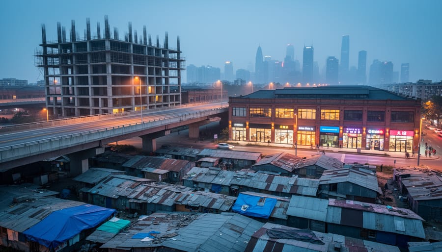
Urbanization is the process by which an increasing percentage of a population concentrates in cities and towns, transforming rural areas into urban centers through economic, demographic, and spatial change. In AP Human Geography, this concept goes far beyond simple population movement. It examines how societies reorganize around urban cores, how infrastructure and services reshape landscapes, and how economic opportunities pull people from agricultural regions into manufacturing and service-based economies.
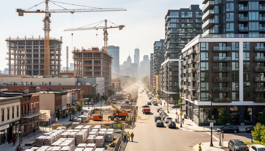
For photographers, understanding urbanization isn’t just academic knowledge. It’s a framework for reading the stories embedded in every cityscape you shoot. That half-finished apartment complex on the urban fringe? It’s evidence of suburbanization. The converted warehouse district now filled with cafes and galleries? That’s gentrification, a specific form of urban change. The informal settlements visible from a highway overpass? They represent rapid urbanization often outpacing infrastructure development, particularly in the Global South.
When you grasp the geographic mechanisms behind urban growth, you see your subjects differently. You recognize that abandoned factory doesn’t just make an atmospheric background. It tells a story about deindustrialization and economic restructuring. The mixed-use development replacing single-family homes reflects deliberate planning principles like New Urbanism. These patterns matter because they reveal power dynamics, migration trends, and social inequalities that give documentary work its depth.
This guide connects the core AP Human Geography concepts of urbanization with practical applications for visual storytellers. You’ll learn the formal definitions used in geographic study, explore the processes that drive urban transformation, and discover how recognizing these patterns strengthens your approach to global visual storytelling. Whether you’re documenting neighborhood change in your hometown or capturing megacity growth abroad, these concepts give structure to what you observe through the viewfinder.
What Urbanization Means in Human Geography
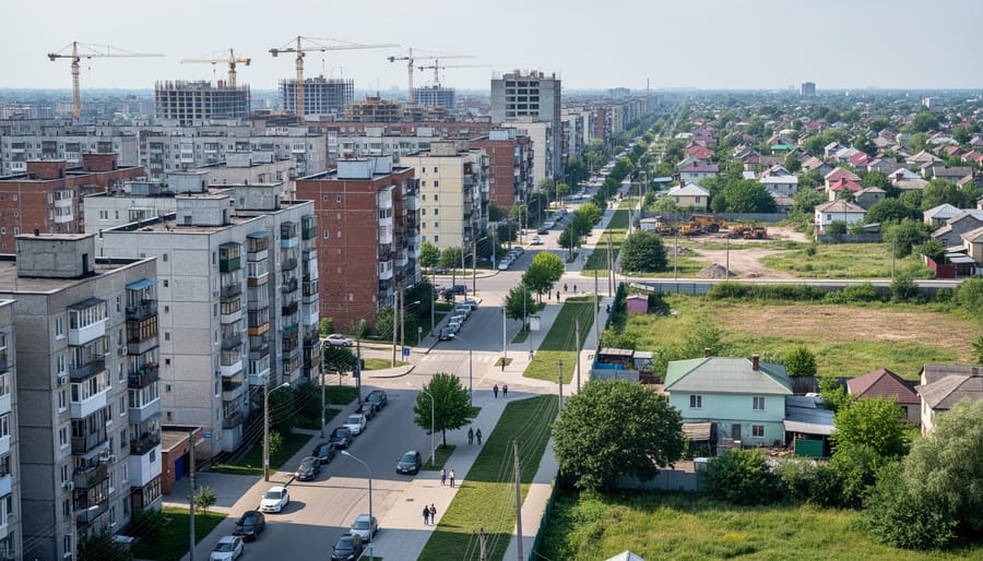
At its core, urbanization describes two interconnected transformations happening simultaneously across the globe. First, it’s a demographic shift where an increasing percentage of a population lives in urban rather than rural areas. Second, it’s a spatial change where cities physically expand their footprint, converting farmland and natural landscapes into built environments of concrete, asphalt, and steel.
The AP Human Geography curriculum defines urbanization as the process by which the proportion of people living in cities rises compared to those in the countryside. This isn’t just about total population growth, it’s specifically about the ratio changing. A country can experience urbanization even if its rural population stays the same, as long as its urban population grows faster. When you photograph a city skyline pushing outward into former agricultural zones, or document new apartment blocks rising where villages once stood, you’re witnessing urbanization in action.
To understand urbanization fully, you need to grasp several related geographic concepts that shape how cities grow and function:
- Urbanization
- The process of population concentration in cities and the physical expansion of urban areas over time. It’s a dynamic transformation, not a static condition.
- Urban Area
- A spatial unit where population density exceeds a specific threshold and most residents work in non-agricultural occupations. Definitions vary by country but typically require several thousand inhabitants and specific density levels.
- Metropolitan Area
- A large population center consisting of a central city plus its surrounding suburbs, satellite cities, and economically connected territories. This captures the functional urban region beyond administrative boundaries.
- Megacity
- An urban agglomeration with over 10 million inhabitants. Examples include Tokyo, Delhi, São Paulo, and Cairo.
- Suburbanization
- The outward growth of cities into surrounding areas, creating lower-density residential zones on the urban fringe. This represents a specific pattern of urbanization common in developed nations.
- Counterurbanization
- The reversal of urbanization, where people move from cities back to rural areas. This phenomenon occurs in some post-industrial societies but remains far less common than ongoing urbanization.
Here’s the crucial distinction that often confuses students: urbanization is the process, while urbanism describes the way of life. Urbanization is the measurable shift of people moving to cities and cities expanding. Urbanism is what happens next, the cultural practices, social relationships, and behavioral patterns that emerge when people live in dense, diverse, fast-paced urban environments. When you photograph street life, informal economies, vertical living, or the anonymity of crowds, you’re documenting urbanism. When you capture construction cranes, new transit lines, or the edge where city meets countryside, you’re documenting urbanization itself.
How Urbanization Works: The Geographic Process
Stages of Urban Growth
Cities don’t explode overnight. They grow through predictable stages that geographers track using the urban transition model. Understanding these phases helps you anticipate what visual stories you’ll find in different cities and when certain neighborhoods become compelling subjects.
The first stage is the pre-industrial city, a small settlement where agriculture dominates and urban populations stay under 10% of the total. Think of rural market towns in parts of sub-Saharan Africa or historical villages in Nepal. These places offer street photography opportunities centered on traditional markets and agricultural life intersecting with emerging infrastructure.
Stage two brings early urbanization, when industrialization pulls workers cityward. Urban populations jump to 25-40% as factories cluster in specific districts. Manchester during the Industrial Revolution exemplifies this phase. Today, cities like Dhaka and Lagos sit firmly in this stage, characterized by rapid informal settlement growth and dramatic skylines rising beside sprawling slums.
The third stage is mature urbanization, where 70-80% of people live in cities. Most developed nations reached this point by the mid-20th century. Tokyo, New York, and Berlin represent this phase, marked by established infrastructure, distinct neighborhoods with century-old identities, and cycles of renewal and decay that create layered visual narratives.
The final stage is counter-urbanization or reurbanization, where growth slows, suburbs sprawl, and some populations shift back to smaller towns or redeveloped urban cores. Post-industrial American cities like Detroit embody parts of this stage, offering photographers abandoned districts alongside revitalized waterfronts.
Categories and Patterns of Urban Development
Primate Cities vs. Rank-Size Distribution
In many countries, one city dwarfs all others in population, economic power, and cultural influence, geographers call this a primate city. Think of Bangkok, which holds over 10 million people while Thailand’s second-largest city barely reaches 200,000, or Buenos Aires dominating Argentina. A primate city typically has at least twice the population of the next-largest city, and it concentrates government, finance, media, and infrastructure far beyond what its size alone would suggest.
For photographers, primate cities offer extraordinary visual concentration. Everything converges in one place: the newest skyscrapers, the oldest neighborhoods, the wealthiest districts alongside the poorest, and the entire national story compressed into a single metropolitan area. You can document nearly every facet of a country’s urbanization just by working this one location.
Rank-size distribution describes the opposite pattern: a balanced urban system where city sizes follow a predictable hierarchy. In the United States, for example, New York leads but doesn’t dominate, Los Angeles, Chicago, Houston, and Phoenix all thrive as major centers with distinct regional importance. The second city has roughly half the population of the first, the third has a third, and so on down the line.
This pattern spreads visual opportunities across geography. Documenting American urbanization means working multiple cities, each with unique character. You’ll find tech innovation in San Francisco, manufacturing history in Detroit, and sprawling sunbelt growth in Phoenix, different stories rather than variations on a single dominant theme.
Where and How Photographers Document Urbanization

Capturing the Human Story Behind the Statistics
Behind every urbanization statistic, every percentage point of urban population growth, every square kilometer of city expansion, are real people reshaping their lives. As a photographer, your most powerful contribution isn’t capturing skylines or infrastructure. It’s documenting the human experiences that numbers can’t convey.
Start by looking for transitional spaces where rural and urban worlds collide. Recent migrants often settle in neighborhoods that blend elements of both identities: rooftop gardens in dense apartment blocks, livestock kept in backyards near highways, traditional cooking methods adapted to high-rise living. These visual contradictions tell migration stories more effectively than any demographic chart.
Community formation in new urban contexts offers rich material. Document how people create social networks in unfamiliar environments, shared courtyard gatherings in housing complexes, informal street markets that become community hubs, religious spaces that anchor displaced populations. Look for moments of mutual support: neighbors helping each other navigate bureaucracy, informal childcare networks, shared meals that recreate village traditions in city settings.
Cultural adaptation provides another crucial dimension. Photograph how traditional practices evolve in urban contexts, festivals compressed into smaller spaces, craftspeople adapting skills to city economies, multi-generational households navigating different rates of cultural change.
When photographing inequality and vulnerable populations, ethical practice isn’t optional. Always seek informed consent. Explain how images will be used. Never photograph people at their most desperate moments without permission for shock value. Avoid reinforcing stereotypes about poverty or migration. Show dignity alongside hardship. Consider whether your presence and camera create harm or discomfort. Share images with subjects when possible. Remember that your work shapes how others see these communities, wield that power responsibly.
Reading Urban Landscapes Through Your Lens
Cities reveal their stories layer by layer if you know how to read them. Geographic literacy transforms you from a casual observer into someone who can decode what makes neighborhoods tick, why certain streets feel abandoned while others pulse with activity, and how power and capital reshape the built environment.
Start by mapping land use with your eyes. Commercial strips anchor the center, industrial zones cluster near transport routes, and residential areas radiate outward in rings or sectors depending on the city’s age and planning history. Walk a neighborhood and note transitions: where does single-family housing give way to apartment blocks? Where do vacant lots interrupt the urban fabric? These breaks in continuity tell stories about disinvestment, speculation, or failed development schemes. Photograph intersections where different land uses collide, a mosque wedged between warehouses, a community garden reclaiming a demolished building’s footprint, street vendors operating in the shadow of luxury towers.
Urban morphology becomes visible once you recognize building types and street patterns. Grid layouts suggest planned development or colonial imposition. Winding streets hint at organic medieval growth or adaptation to topography. Photograph from elevated vantage points to capture these patterns: fire escapes, parking garages, and accessible rooftops offer perspective that reveals how cities are structured spatially.
Gentrification leaves visual signatures worth documenting. New coffee shops in formerly working-class areas. Fresh paint on century-old storefronts. Construction fencing promising “luxury lofts” where factories once stood. Photograph the friction points: longtime residents outside corner stores flanked by yoga studios, boarded-up businesses beside high-end boutiques, murals protesting displacement. These juxtapositions matter for migration photography documenting how economic forces push communities out and reshape cultural diaspora patterns within cities.
Scout locations with census data in hand. Demographic maps reveal ethnic enclaves, income disparities, and language boundaries, invisible lines that structure daily urban life. Religious buildings, specialty grocery stores, and street signage mark these territories. Documenting these spaces connects to broader themes like gender across cultures showing how different communities claim and use public space.
Cities aren’t random. They’re organized by economic forces, political decisions, and social hierarchies. Your camera becomes an analytical tool when you understand the geographic logic behind what you’re framing.
Common Questions About Urbanization and Visual Documentation
How do geographers actually measure urbanization?
Urbanization is measured by calculating the percentage of a country’s population living in areas classified as urban, typically settlements over a certain population threshold. Geographers also track urban population growth rates and the physical expansion of built-up areas using satellite imagery and census data.
What’s the difference between urbanization and suburbanization?
Urbanization is the overall shift of population from rural to urban areas, while suburbanization describes the outward growth of cities into surrounding areas. Suburbanization is actually a phase within the urbanization process, creating low-density residential zones beyond the city core.
How do you photograph urban sprawl effectively?
Capture sprawl from elevated positions or aerial perspectives to show the repetitive patterns of development extending into former agricultural land. Look for edge zones where suburban development meets rural landscapes, and document infrastructure like highways that enable sprawl.
What are the biggest challenges when documenting megacities?
Megacities present access challenges, particularly in informal settlements and restricted areas. The sheer scale makes it difficult to represent the city comprehensively, and photographers must navigate complex power dynamics, security concerns, and ethical considerations when documenting inequality.
How does urbanization connect to globalization?
Urbanization and globalization reinforce each other as cities become nodes in global economic networks, attracting international investment and migrants. This connection creates opportunities to photograph cultural hybridity, economic integration, and the tension between local traditions and global influences in rapidly changing urban spaces.
Can photographers contribute to geographic understanding of urbanization?
Yes, documentary photography provides visual evidence of urban change that complements statistical data. Long-term photo projects documenting neighborhoods, time-lapse imagery of construction, and work capturing displaced communities or indigenous visual language in urban contexts all contribute valuable qualitative data to geographic research.
These questions arise repeatedly in both geography classrooms and photographer forums, often when someone realizes that technical skill alone does not fully capture what is happening in cities. Understanding the measurement methods behind urbanization statistics helps you evaluate which cities are changing fastest and where compelling stories might unfold. Recognizing suburbanization as distinct from core urbanization lets you frame your work more precisely when pitching stories or organizing portfolios.
The practical photography questions about sprawl and megacities reflect real frustrations. Sprawl is visually repetitive and requires deliberate compositional choices to avoid boring your audience. Megacities overwhelm with their complexity and present logistical barriers that small-town photographers rarely encounter. Knowing these challenges in advance lets you plan better, whether that means securing drone permits, hiring local guides, or building relationships with community organizations before you start shooting.
The globalization question matters because cities are where global forces become visible on the ground. A container port, a multinational corporate headquarters, a neighborhood of recent immigrants, traditional markets selling global goods, these subjects tie urbanization to larger economic and cultural shifts. Your photographs gain depth when you can place local changes within these broader patterns.
Understanding urbanization as geographers do transforms you from someone who photographs buildings into someone who reads cities. When you recognize a primate city’s dominance, spot the telltale signs of gentrification, or identify informal settlement patterns, your images carry weight beyond their aesthetic appeal. They become evidence of forces reshaping our world.
The geographic concepts from AP Human Geography, push-pull migration factors, urban hierarchies, spatial organization, aren’t abstract classroom theories. They’re frameworks for understanding what you see through your viewfinder. That construction crane tells a story about capital flows. The informal market reveals economic adaptation. The empty storefront speaks to displacement pressures you can now name and contextualize.
Geography gives you the vocabulary to articulate what makes a location significant beyond “it looks interesting.” Your captions gain precision. Your project proposals demonstrate genuine insight into urban systems. Most importantly, you photograph with empathy and awareness, understanding that behind every visible change are people navigating one of history’s great migrations.
We’re witnessing the largest movement of humans in history: three billion people have urbanized in the past fifty years, with another three billion expected by 2050. Cities will define this century. As photographers, we hold the tools to document this transformation in ways statistics never could, showing the texture, the faces, the contradictions, the resilience.
Study how cities work. Your photography will show not just what urbanization looks like, but what it means.




 By
By